A deep dive into recommended transportation projects for Stittsville
Staff released "TMP Part 2 – Capital Infrastructure Plan" for consultation last week
On April 1 City staff released the draft list of recommended transit and road projects for the Transportation Master Plan. There are several much-needed projects to accommodate growth in Stittsville, and I’ve been asking residents to share their feedback by completing the surveys at engage.ottawa.ca.
I think it’s worth doing a deeper dive into the information, and to provide more context about what we’re asking you to comment on. I’m focusing here on Stittsville and the west end, but I hope it’s an entry point for people in other parts of the city as well to understand what’s in the draft plan.
Background
The last time the City did a Transportation Master Plan (TMP) was in 2013, and that document is getting increasingly out of sync with changing growth patterns and transportation needs.
The new TMP will set out how the city would plan, develop and operate, its walking, cycling, transit and road networks over the next few decades. It’s meant to reflect the City’s new Official Plan (2022) by accommodating population growth to 2046, and supporting a shift to sustainable transportation modes (walking, cycling, transit).
In 2023 City Council approved TMP Part 1 – Policies along with recommended Active Transportation Projects (cycling and sidewalks). You can read more about Part 1 here…
Now we’re into TMP Part 2 – Capital Infrastructure Plan with recommendations for major transit and road projects across the city. It prioritizes projects based on how affordable they are within the City’s long-range financial plans. You can read the highlight reports and more documentation here…
City staff are collecting resident feedback on “Part 2” now, with final recommendations coming to City Council for approval in July 2025.
We’re growing, and travel patterns are changing
The population of Ottawa is expected to grow from 1,064,000 in 2021 to approximately 1.4 million by 2046. To develop the recommendations and prioritization, City staff did extensive review and modeling of how people will move around Ottawa. Some highlights:
By 2046, we expect to see demand for an additional 1.2 million daily trips, including more than 620,000 driving trips.
The largest growth in car trips involves trips between suburban and outer urban areas. Many roads across the Greenbelt will be congested, and additional localized congestion hot spots are expected, especially within suburban communities, on two-lane arterial roads near the urban boundary, and at crossings of the Rideau River.
The proportion of trips by transit (i.e. the transit mode share) is projected to increase between 2022 and 2046. This reflects, in part, a return to downtown- based in-office employment compared to 2022, as well as the opening of Stage 2 O-Train extensions.
Transit trip growth is most prominent in downtown and inner urban-oriented neighbourhoods. There is also significant suburban and outer urban transit trip growth, largely destined to the downtown and inner urban areas along the O-Train and Transitway corridors.
(I did a deep dive last year into the Origin-Destination Study, one of the major studies that staff are using to develop the TMP priority list. You can also read additional technical reports at engage.ottawa.ca.)
Transit
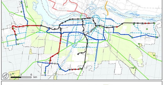
This first map shows the “Needs Based Transit Network”, including major transit projects needed based on population and employment growth projections to 2046. The total capital cost of the projects is $4.9-billion, plus $8.3-billion for the O-Train Stage 3 extensions to Stittsville, Kanata, and Barrhaven. That’s a total of $13.2-billion for transit.
West end projects include LRT to Hazeldean Station in Stittsville; a Transitway along Robert Grant from Hazeldean to Fernbank, and a Transitway along March Road to Kanata North.
The dotted blue lines are “Transit Priority Corridors”, including Hazeldean, Stittsville Main, and Fernbank. These roads would be upgraded with features to reduce transit delays and improve reliability: queue jump lanes, transit signal priority at intersections, changes to bus stop configurations, and other low-cost tactical changes.
$13.2-billion is a massive capital investment, and even with assistance from the provincial and federal governments it will be a challenge to find the money to move ahead with every project on the list.
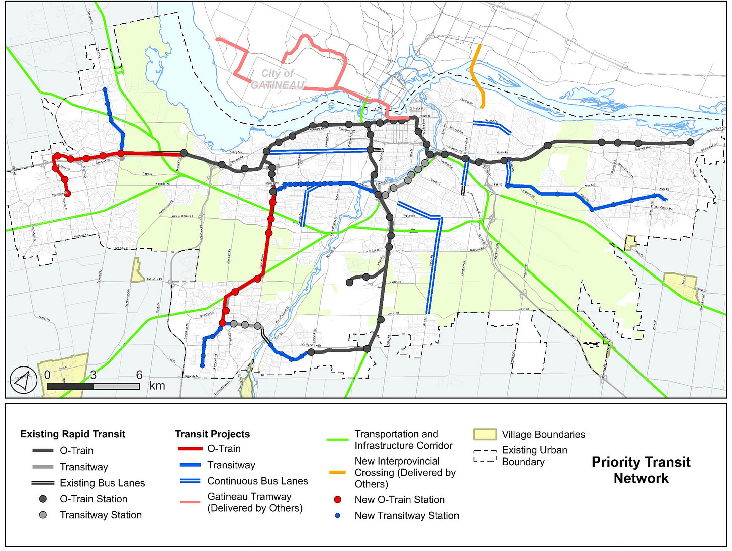
This second map shows the Priority Transit Network, focusing on the highest priority projects and the most critical transit infrastructure. The LRT to Hazeldean Station in Stittsville, and the Kanata North Transitway are on this priority list. Total cost is $2.2-billion, plus $8.3-billion for the LRT Stage 3 projects.
(A note: LRT to Stittsville, Kanata, and Barrhaven is based on the assumption that the provincial and federal governments would fund 100% of the cost. If that funding does not come through, it’s likely we would see some combination of LRT and Transitway along these corridors.)
Roads
Staff have grouped recommended road projects into a number of categories. All projects to build new (or widened) roads including walking, cycling, and/or transit infrastructure. Here’s an overview, focusing on Stittsville.
Committed projects – already underway or very close to start of construction.
Carp Road South widening from two to four lanes between Highway 417 and Hazeldean Road, plus an upgrade of the Carp-Hazeldean intersection. Construction starts later in 2025.
Robert Grant Avenue Extension: from Abbott Street to Hazeldean Road. Currently under construction, with completion expected in Fall 2025.
Similar to transit, staff created a “Needs Based Road Network” and a refined “Priority Network” for roads. Most of the priority projects in the west end are in Stittsville. The cost for all Priority Network construction city-wide is $1.1B.
Phase 1 projects, completed within the next ten years
Stittsville Main Street Extension: Maple Grove Road to Derreen Avenue – $8-million.
Robert Grant Extension: Hazeldean Road to Palladium Drive – $88-million.
Terry Fox Drive: Winchester Drive to Castlefrank Road / Abbott Street – $34-million.
Urbanization and Mainstreet improvement projects
Upgrades to existing streets to improve the walking and cycling environment, without adding vehicle capacity.
Fernbank Road: West Ridge Drive to Shea Road
Maple Grove Road: East of Huntmar Road to Terry Fox Drive
Shea Road: Abbott Street to Cosanti Drive
Hazeldean Road: Carp Road to West Ridge Drive
Stittsville Main Street: Hazeldean Road to Bobcat Way (implementing the Stittsville Main Street Public Realm Plan)
Active Transportation (sidewalks and pathways)
There are several Stittsville sidewalk/pathway projects on the priority list:
Hobin Street sidewalk from Carp Road to Crossing Bridge Park.
Multi-use Pathway along Johnwoods Street between Alon Street and Rosehill Avenue. (already completed)
Sidewalk along West Ridge Drive from Sable Run Drive to Alfred McCoy Park.
Cycling connection across Stittsville Main St for the Trans Canada Trail and other improved connections to the Trans Canada Trail.
Multi-use pathway connection from Echowoods Park to Feedmill Creek Recreational Trail.
Multi-use pathway connections along Terry Fox Dr from Westphalian Ave to Condado Cres, and a feasibility review of a crossing of Fernbank Rd near Brigitta Park. (some of this work will start this year)
Bike lanes where feasible on West Ridge Dr from Beverly St to Stittsville Main St.
Multi-use pathway from Terry Fox Dr to Hazeldean Rd along the Carp River.
Feasibility study of a Hwy 417 underpass to extend the Carp River pathway system from Frank Nighbor Place to Roger Neilson Way.
What’s not in the plan
I’ve done a preliminary review of the documentation and so far I’ve found two fairly big changes to previously-planned capital work:
The 2013 TMP recommended an upgrade to Huntmar Drive north of Maple Grove, with construction starting before 2031. This project has been removed from the 2025 recommendations because new data and modelling showed that the additional road capacity isn’t needed – especially with the Robert Grant extension from Hazeldean to Palladium.
The recently-completed Environmental Assessment work for the Huntmar Drive project identified a need for a safe crossing over the Queensway for pedestrians and cyclists. That’s not in this recommended project list due to high cost, but we still need a solution. (There is a feasibility study for a 417 underpass to connect the Carp River pathway system north and south of the Queensway.)
Also worth noting that the list of road projects in the TMP includes major roads only. There are additional road and active transportation projects in new subdivisions that will be built by developers. For example, Cope Drive will still connect to Shea Road when the developer moves forward soon with their subdivision, probably later in 2025.
Remember that this a capital infrastructure plan, so it does not touch on operational needs like frequency of buses or snow removal.
Share your feedback
With this info in mind, here’s how you can share your feedback:
Share your input by completing the online surveys available on the Transportation Master Plan project page. Surveys will be open until May 12.
Attend a public engagement session – virtual and in-person events will run from April 8 to May 6. See a list of all engagement events here. There’s a virtual session for the west end on Thursday, April 24.
Send your comments or questions to me! Here’s my councillor contact info.


